Has the use of the Mercator map misled people’s knowledge of Africa’s true size?
The United Nations (U.N.) has begun to phase out the Mercator Projection map in favour of more accurate, less biased projections. However, we continue to see its impact on education and geopolitical power dynamics almost 460 years after it was created by Flemish cartographer Gerardus Mercator.
How can Africa move forward if the remnants of a Eurocentric past is holding it back?
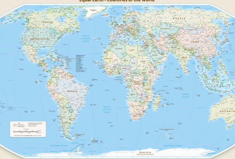
Equal Earth projection
On Sept. 4, 2026, the U.N. passed a progressive resolution encouraging the world to adopt the Equal Earth projection, an equal area map. 164 countries voted in favour of the resolution, with six abstenting: Estonia, Georgia, Lithuania, Moldova, Serbia, and Ukraine. The United States voted against it.
Equal earth projection is based on the principles first introduced to the world with the Galls-Peter Projection, created by James Gall in 1885, and then popularized by Arno Peters in 1973. The new map was created in 2018 by Bojan Šavrič, Tom Patterson, and Bernhard Jenny initially as an alternative to the Robinson projection, which distorts true landmass sizes.
Misleading!
Criticism has arisen over the impact Mercator Projection map has had on the education of the general public and the misleading perception of Africa’s true projections, which leads to political misinterpretations.
For instance, Russia, Europe’s biggest country, is depicted as larger than the whole continent of Africa in the Mercator Projection. In reality, Africa is 1.8 times larger than Russia, and could fit Russia inside the continent with plenty of room left over. In fact, the U.S., China, India, Turkey, Greece, etc., many more countries could still all easily fit inside Africa, leaving plenty of room.
Togolese Minister of Foreign Affairs Robert Dussey affirms that diminishing Africa’s scale on the map leads to a distorted perception that it is less significant of a continent than it actually is.
“This initiative reminds the world that the way maps represent places also influences how people are perceived,” he said.
Not a pressing issue according to the U.S.?
The U.N. resolution has been introduced, spearheaded, and sponsored by Togo on behalf of the African Union, with Dussey taking the leading role in negotiations.
However, those who oppose the new U.N. map resolution, like the U.S., do so out of the concern that the motive is too much of an ideological initiative.
The deputy U.S. representative for the U.N. Economic and Social council, Yaryna Ferencevych, expressed her belief that the U.N. should focus on more pressing geopolitical issues over taking on “ideological agendas” such as this. Otherwise, it would compromise the U.N.’s impartial leadership and credibility on the world stage.
“Instead of focusing on genuine problems… this body is debating map projects from the 16th century,” said Ferencevych.
Too many who share Minister Dussey’s view think initiatives such as this one are trivial agendas that take the U.N.’s attention away from more pressing concerns. In fact, they are the building blocks for Africa as a continent to be given more recognition and agency, rather than be sidelined and diminished in favour of the literal and figurative aggrandizement of primarily Western states.
Part of the issue is, as Africa tries to move forward, it is held back by the antiquated ideas of the past. While it may not have been the original intent of the Mercator map, the lingering colonial views that dismiss Africa and the Global South in favour of aggrandizing the Global North still persist.
This can lead to misinterpreted data which in turn contributes to how policies are influenced. The Equal-Earth projection map is a way forward on the path of shedding these antiquated concepts to a more equitable, fair future.
As Africa tries to move forward, it is held back by the antiquated ideas of the past. While it may not have been the original intent of the Mercator map, the lingering colonial views that dismiss Africa and the Global South in favour of aggrandizing the Global North still persist. -Yaniet Abebe
Both maps have advantages and trade offs
Despite that, because the Equal Earth projection map prioritizes depicting the true relative surface size of Africa and South America, it loses geometric accuracy elsewhere.
Some detractors might argue that the Equal Earth projection map has its own bias if it’s still compromising full accuracy of shape, true distance, navigation direction, etc., in favour of a larger size for Africa.
What must be kept in mind is that, in cartography, it’s mathematically impossible to take the three dimensional sphere that is earth and flatten it into any two dimensional map, so the Equal Earth projection map was made to compromise accuracy in the overall shapes, angles, distance, and direction, of countries.
The Mercator map was initially created for navigation so it focused on direction, and is still relevant in digital navigation as it maintains the more accurate details of shapes and angles. Because of that, it inflates the size of high latitude countries, where it instead focuses on direction.
Moreover, it is not only Africa that is distorted on the Mercator map, but generally countries closer to the equator are closer to their true size or depicted as smaller, such as India and China, which in reality are 1.5 times and 4.4 times larger than Greenland respectively, but depicted as smaller than Greenland because it is closer to the Equator.
The U.N.’s leadership as an impartial entity includes ensuring that accurate, equitable, and fair representation of data is maintained, rather than allowing a distorted map to form a misconstrued perception of the world.
This new resolution in favour of the Equal Earth Projection map is a significant step towards fairer representation of Africa on the world stage, reminding us that our own perceptions, public policy, geopolitical relations, and data are not always reliable. Oftentimes, our understanding of the world is only as accurate as the maps and data used to view it.